
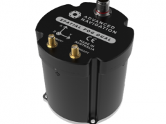
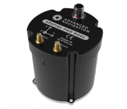

Spatial FOG Dual為雙天線光纖陀螺儀組合導航系統。相比Spatial FOG光纖陀螺儀慣性測量單元,更加適合普及應用于海陸空測繪行業,也適合天線追蹤、直升機、極限運動、機器人等。
Spatial FOG Dual features dual antenna moving baseline RTK. This allows it to provide highly accurate heading while both stationary and moving. It is an excellent choice for applications with low dynamics where single antenna systems struggle or any application where additional heading accuracy is required. An added benefit is the ability to accurately measure vehicle slip angle.
Spatial FOG Dual contains the KVH Industries 1750 fibre optic gyroscope (FOG) IMU, which provides extremely accurate inertial data far beyond the best MEMS technology available. This allows Spatial FOG Dual to acheive very high accuracies and dead reckon without GNSS for extended periods of time. Despite the high accuracy FOG IMU, Spatial FOG Dual has a very competitive price tag that is lower than many MEMS systems on the market.
Spatial FOG Dual contains a dual frequency Trimble RTK GNSS receiver that provides up to 8mm accuracy positioning and supports all of the current and future satellite navigation systems, including GPS, GLONASS, GALILEO and BeiDou. It also supports the Omnistar service for hassle free high accuracy positioning. Spatial FOG Dual supports both real time RTK positioning and logging of raw satellite data for kinematic post-processing.
Spatial FOG Dual contains Advanced Navigation's revolutionary sensor fusion filter. The filter is more intelligent than the typical extended kalman filter and is able to extract significantly more information from the data by making use of human inspired artificial intelligence. It was designed for control applications and has a high level of health monitoring and instability prevention to ensure stable and reliable data.
Spatial FOG Dual contains a next generation battery backup system that allows it to hot start inertial navigation from its last position in 2 seconds and obtain a GNSS fix in approximately 3 seconds. The battery backup system lasts for the lifetime of the product and will provide backup for 48 hours without power. Advanced Navigation's Spatial series are the only GNSS/INS in the world to provide hot start inertial navigation.
Spatial FOG Dual has been designed from the ground up for mission critical control applications where reliability is very important. It is built on top of a safety oriented real time operating system and all software is designed and tested to safety standards with fault tolerance in place. The hardware is protected from reverse polarity, overvoltage, surges, static and short circuits on all external interfaces. The GNSS contains RAIM, which excludes both malfunctioning, and tampered satellite signals. Spatial FOG Dual contains a backup MEMS IMU, which it can seamlessly fall back to should the primary IMU fail.
Spatial FOG Dual's internal filter runs at 1000Hz and data can also be output at this rate over high speed RS232 or RS422. This allows for control of dynamically unstable platforms.
Spatial FOG Dual features two general purpose input output pins and two auxiliary RS232/RS422 ports that support an extensive number of peripherals. Including odometer based input for ground vehicles, DVLs and USBLs for underwater navigation, NMEA input/output and more. For an integration fee, custom peripheral devices can be added.
APPLICATIONS應用
Spatial FOG Dual is ideal for marine surveying applications, providing all the reference data required in a single unit. It provides a very high accuracy source of real time roll, pitch and heading as well as RTK accuracy positioning ideal for referencing subsea points. It features a revolutionary tightly coupled heave filter that provides heave accuracy surpassing most post processed heave systems. It also supports Omnistar for enhanced accuracy positioning offshore.
Spatial FOG Dual's high accuracy roll, pitch and heading make it well suited for surveying applications. It supports RTK which allows it to provide dramatically enhanced positioning accuracy over standard GPS with positioning accuracy of 8mm. The system supports connection of a high resolution wheel speed sensor or odometer which allows it to maintain accurate data through GPS outages and continue surveys through tunnels and other areas where GPS signals are not available. It also supports output of RINEX raw satellite data for post processing.
Spatial FOG Dual is ideal for use in helicopters where high levels of magnetic interference make magnetic heading unusable. In this application, single antenna GNSS/INS systems can have issues resolving the heading due to the 3D movement and stationary hovering of the platform. Spatial FOG Dual is able to provide very high accuracy heading under all conditions whether stationary or moving and through all levels of magnetic interference.
In both stationary and moving antenna applications, Spatial FOG Dual provides a high accuracy source of roll, pitch and heading that is ideal for antenna targetting control. Its ability to provide continuously reliable data through extended GPS outages and interference means that systems can maintain very high uptimes.
Spatial FOG Dual is an excellent tool for performance measurement in motorsport. From the velocity and orientation data, slip, oversteer and understeer can be calculated. The velocity and acceleration data can be used to calculate improvements to braking and accelerating. Position can be used to determine the deviation from the optimum track position. Spatial FOG Dual’s high vibration tolerance and dynamic range means there are no concerns about engine or road vibration. Spatial FOG Dual also supports data output to data acquisition systems such as Dewesoft products.
Spatial FOG Dual’s accurate orientation data allows for stabilization of robotic systems and its position, velocity and acceleration data can be used for robot navigation. Spatial FOG Dual’s high update rate allows it to control dynamically unstable platforms and its focus on safety and reliability provides for piece of mind.
SPECIFICATIONS規格書
| Horizontal Position Accuracy | 0.8 m |
| Vertical Position Accuracy | 1.5 m |
| Horizontal Position Accuracy(with SBAS) | 0.5 m |
| Vertical Position Accuracy(with SBAS) | 0.8 m |
| Horizontal Position Accuracy(with RTK) | 0.008 m |
| Vertical Position Accuracy(with RTK) | 0.015 m |
| Velocity Accuracy | 0.005 m/s |
| Roll & Pitch Accuracy | 0.01 ° |
| Heading Accuracy | 0.01 ° |
| Slip Accuracy | 0.01 ° |
| Heave Accuracy | 2 % or 0.02 m (whichever is greater) |
| Orientation Range | Unlimited |
| Hot Start Time | 2 s |
| Internal Filter Rate | 1000 Hz |
| Output Data Rate | Up to 1000 Hz |
| Sensor | Accelerometers | Gyroscopes | Magnetometers | Pressure |
| Range | 10 g | 490 °/s | 8 G | 10 to 120 KPa |
| Noise Density | 120 ug/√Hz | 0.8 °/hr/√Hz | 210 uG/√Hz | 0.56 Pa/√Hz |
| Non-linearity | < 0.03 % | < 0.005 % | < 0.05 % | - |
| Bias Instability | 50 ug | 0.05 °/hr | - | 100 Pa/yr |
| Scale Factor Stability | < 0.06 % | < 0.02 % | < 0.05 % | - |
| Cross-axis Alignment Error | 0.05 ° | 0.02 ° | < 0.05 ° | - |
| Bandwidth | 200 Hz | 440 Hz | 110 Hz | 50 Hz |
| Model | Trimble MB-One |
| Supported Navigation Systems | GPS L1, L2 GLonASS L1, L2 GALILEO E1 BeiDou B1 |
| Supported SBAS Systems | WAAS EGNOS MSAS GAGAN QZSS Omnistar HP/XP/G2 Trimble RTX |
| Update Rate | 20 Hz |
| Hot Start First Fix | 3 s |
| Cold Start First Fix | 30 s |
| Horizontal Position Accuracy | 1.2 m |
| Horizontal Position Accuracy (with SBAS) |
0.5 m |
| Horizontal Position Accuracy (with RTK) |
0.008 m |
| Velocity Accuracy | 0.005 m/s |
| Timing Accuracy | 20 ns |
| Acceleration Limit | 11 g |
| Interface | RS422 (RS232 optional) |
| Speed | 4800 to 10M baud |
| Protocol | AN Packet Protocol or NMEA |
| Peripheral Interface | 2x GPIO and 2x Auxiliary RS232 |
| GPIO Level | 5 V or RS232 |
| GPIO Functions | 1PPS Odometer Stationary Pitot Tube NMEA input/output Novatel GNSS input Trimble GNSS input AN Packet Protocol input/output Packet Trigger Input Event Input |
| Operating Voltage | 9 to 36 V |
| Input Protection | -40 to 100 V |
| Power Consumption | 510 mA @ 12 V (typical) |
| Hot Start Battery Capacity | > 48 hrs |
| Hot Start Battery Charge Time | 30 mins |
| Hot Start Battery Endurance | > 10 years |
| Operating Temperature | -40 °C to 75 °C |
| Environmental Protection | IP67 MIL-STD-810G |
| MTBF | > 36,000 hrs |
| Shock Limit | 40 g |
| Vibration | 12 g |
| Dimensions | 94x94x95 mm |
| Weight | 740 grams |
Ordering Information訂貨信息
Part Number:SPATIAL-FOG2-EK Description:Spatial FOG evaluation Kit
Notes: Spatial FOG evaluation kit Includes items listed in section 6.1 L1 GPS, GLONASS, BeiDou, SBAS DGNSS supported License required for RTK, L2, L5, Galileo and raw data logging
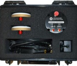
Spatial FOG Dual evaluation Kit
Spatial FOG Dual evaluation Kit rugged transport case
Part Number:SPATIAL-FOG2 Description:Spatial FOG Unit
Notes:Spatial FOG unit L1 GPS, GLONASS, BeiDou, SBAS DGNSS supported License required for RTK, L2, L5, Galileo and raw data logging No cables included
Part Number:SPATIAL-FOG2-NOGNSS Description:Spatial FOG Unit (No GNSS)
Notes: Spatial FOG unit without internal GNSS receiver No cables included
Part Number: SF-LIC-8MM Description: RTK, L2, L5, Raw Data and Galileo License Upgrade
Notes: GNSS receiver software license upgrade that enables RTK, L2, L5, Raw Data and Galileo
Accessories:
Part Number:SF-DU-KIT Description:Spatial FOG Dual Antenna Upgrade Kit
Notes:Upgrades Spatial FOG to be a dual antenna system for enhanced heading See section 10.5.3
Part Number:8071-4336-78 Description: Unterminated Interface Cable
Notes:Spatial FOG connector with 2 metres of unterminated cable See section 8.9
Part Number:SF-CABLE-KIT Description: Spatial FOG evaluation Cable Harness
Notes:Spatial FOG connector with 2 metres of cable to industry standard connectors See section 8.10
Part Number:BF046WS140612-06 Description: Right Angle SMA to TNC 4m Cable
Notes:Right Angle SMA to TNC connector 4 metre antenna cable
Part Number:G5Ant-53A4T1 Description:Antcom GNSS Antenna
Notes:Antcom G5 L1/L2/L5 GNSS antenna with survey mount
Part Number:57970-10-INT Description:Trimble Zephyr GNSS Antenna
Notes:Trimble Zephyr 2 L1/L2/L5 GNSS Antenna
Part Number:OBDII-ODOMETER Description:OBDII Odometer Notes:OBDII Odometer Interface See section 9.8.2
Part Number:AD-UNIT Description: Air Data Unit Notes:Air data unit provides pitot and static air data aiding for Spatial FOG in fixed wing aircraft
Part Number:MOUNT-SUCT Description:Suction Cup Antenna Mount
Notes:Suction cup 5/8” GNSS antenna survey mount for easy installation of GNSS antenna on vehicles
base station radio modem RTK corrections: base station radio modem RTK corrections require two additional pieces of hardware, these are the base station and the radio modem receiver. The base station is setup at a fixed location and transmits corrections to the radio modem receiver that is connected to the mobile Spatial FOG unit. The radio modem receiver and Spatial FOG unit must remain within range of the base station to receive these corrections, typically this range is approximately 20km. We recommendTrimble R8sRTK base station.


 ?
?